thebillshark
Key Tower 947'
-
Joined
-
Last visited
Everything posted by thebillshark
-
no I meant both around the campus and around the town. I read that a windbreak with tall enough trees can disrupt the wind for over 1,000 ft, perhaps if you had that as a first line of defense the buildings and trees of the town would cause additional friction and it would be enough to reduce the wind. In any case if the golf course is now defunct they could plant a windbreak of trees very close to campus aimed at blocking the cold wind from the north.
-
thebillshark replied to The_Cincinnati_Kid's post in a topic in Southwest Ohio Projects & ConstructionI think they should put the the garage underground and keep Logan Street open. Building an above ground garage in the proposed location will totally cut off sunlight to existing buildings to the north on Logan Street. Above ground space in Over the Rhine should be for people and buildings. The street and sidewalk interface in Over the Rhine is what people are attracted to and blocking off Logan would be taking some of that away for good. We only have one Findlay Market and one chance at this so I hope we don’t ruin it with mediocre design and mediocre creativity and mediocre thinking
-
I’ve become somewhat obsessed with this idea since posting about it. Not just for Bowling Green but for other small towns in Ohio. i might create a separate topic. looking at Google maps alone, a lot of Ohio’s county seat sized towns are remarkably similar. They have similar things on the outskirts- county fairgrounds, a high school complex, a park with softball fields, maybe a cemetery, golf course, or water plant, and a Walmart super center. It looks like you could build a bike trail around or connecting or going through some of those things but maybe you couldn’t build a complete circle all the way around the town because of sprawl in one direction or another. A handful have existing trails or are near state parks already. It looks like Oxford (Miami U) has a trail network to the east of town but it does not encircle the town to the west.
-
I've heard Bowling Green has strong winter winds coming in from the flat land surrounding it. I wonder if they could mitigate the wind by purchasing a ring of farmland around the town and use it to regrow forest/wetlands. Perhaps even moving the airport out further and replacing the current one with a large park. Even if it wasn't completely effective against wind such a project could provide recreation and education opportunities. just from google maps it doesn't look like there are a lot of natural areas for outdoor recreation in the immediate area. They could build a greenbelt trail encircling the town before sprawl makes it completely impossible
-
an air gondola to the Covington IRS development
-
the rendering shows the main commercial building fronting up against the street but the site pan shows it set back in a parking lot?
-
I wonder if this development is successful (all indications are that it will be) if some of the smaller office buildings along Carver Rd. will be redeveloped into residential and connected to this development. There’s kind of a creek/ditch separating the old airport land where the new development is from the office park buildings along Carver. I wonder if we’ll see additional connections across it (would be good for office workers to access the restaurants and walking trails.) also that bottom street should be extended across the “future development” area to meet the traffic circle
-
thebillshark replied to buildingcincinnati's post in a topic in Southwest Ohio Projects & ConstructionRe: road design options. I think that business district needs on street parking. I would go with option 1 with the following changes: extend the curb and enlarge the sidewalk by 2’ by reducing the travel lane from 12’ to 10’. That way you get a refreshed sidewalk streetscape too. And also demarcate the individual parking spaces with paint on the ground so visually the side of the street with parking doesn’t appear to be an 18’ travel lane if no one is parked there. re: intersection options. Would be interested to see a roundabout option. It appears they are willing to take out the BP with the existing options so I wonder if a roundabout would fit.
-
wow- would love for them to build an office for logistic jobs at the Covington KY IRS site (to support CVG hub)
-
We talk a lot about light rail to the airport but what about other types of rail links? It looks like most of the existing tracks in Kentucky don’t point towards the airport. Does it have a rail link of any sort? Would it benefit from some kind of freight link? What about an intercity passenger rail connection like Amtrak? Does suburban sprawl eliminate the possibility for this?
-
-
thebillshark replied to The_Cincinnati_Kid's post in a topic in Southwest Ohio Projects & Constructionwow that buildings relationship to McMillan St. could really be improved. In the article you can see it used to have a grand entrance facing the street. Restoring that would change the feel of the whole block
-
I wonder if tri-county and forest fair mall could be re-made into industrial sites. Both have awesome interstate access and tri-county is rail-adjacent. Both are on or near bus routes that could be used by workers from the city. They could re-use the parking garages to save land and build a larger industrial factory/facility or even multiple facilities on the sites.
-
opening up those first floor bricked-up bays in the Kroger building for some kind of storefront use would really help this project. I wonder how feasible that would be
-
thebillshark replied to buildingcincinnati's post in a topic in Southwest Ohio Projects & ConstructionI’m concerned blocking off Elm will be considered as a “preliminary” or “conceptual” option until all the sudden one day it’s the only way for a hundred million dollar plan to work and oh by the way we need a council vote by Wednesday.
-
thebillshark replied to buildingcincinnati's post in a topic in Southwest Ohio Projects & ConstructionIf they block off Elm Street or sink it into a trench for the convention center expansion they will create hard, people-and-activity blocking borders for those quadrants right through the center of town. A generational mistake in the making
-
thebillshark replied to buildingcincinnati's post in a topic in Southwest Ohio Projects & Constructionthats why it’s good the bike trail is progressing along like it is.
-
thebillshark replied to buildingcincinnati's post in a topic in Southwest Ohio Projects & ConstructionYes, light rail would take forever to implement and there is great value in having this bike trail now. Perhaps someday light rail or autonomous subway can intersect with the trail which could feed the rail line with commuters on e-bikes which would be a good setup as well.
-
i would be all for a separate program that extended grants or credits to transit oriented development. But in terms of using this emergency stimulus money for transit to stray from the core mission and pivot into development, the idea would play terribly across the political spectrum from left to right, and erode support for additional funding. Even if the everything goes 100% right with the development (which it won’t.) Use the money to run a good transit system and development will follow.
-
Sorry, I don’t think this would be a good use of the transit funds headed for Cincinnati. Transit funding in our region is won through steel cage wrestling matches and back alley knife fights, in contrast there is nearly an infinite variety of programs already in place for developers to add to their “capital stack.”
-
Yes I was wondering if they were planning the same thing. I wonder which parts of the complex are historic and which parts are not? Even parts that look modern from the outside might have historic interior or subterranean parts? it’d be neat to use the multiple garage bays all around the exterior for a series of workshop/artisan/light industrial type businesses, if unlikely.
-
thebillshark replied to The_Cincinnati_Kid's post in a topic in Southwest Ohio Projects & ConstructionAwesome! This is great news.
-
Kansas City has 2 big centers of activity that line up in a straight line with no steep hills in the way connected by a wide road (3 lanes in each direction) named “Main St.” Their route and proposed extension routing were always kind of obvious compared to ours...
-
I initially thought is was too much too until I realized the key idea is to separate the I-75 traffic from the Central Parkway to Fairmount local traffic. This is critical for transit, bus or potential future rail, because it eliminates traffic lights for an I-75 exit for vehicles traveling from Central Parkway to Fairmount and reduces traffic friction for these vehicles. Meanwhile having two lanes in each direction for this local traffic means one of them could be dedicated to transit someday. It’s also critical to pedestrians because the path doesn’t go though some I-75 exit configuration that would be unpleasant/dangerous to walk through. so i think it’s a good design. i would like to see a wide mix used path on both the south and north sides of the viaduct and plan on reaching out to them with that comment.
-
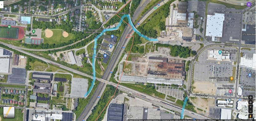
thebillshark replied to buildingcincinnati's post in a topic in Southwest Ohio Projects & ConstructionThe bike trail almost maps out itself with the existing RR underpass and bridge over I-71. Would connect all the new developments together and to Norwood's Waterworks Park via Harris Ave. The question is, could Cincinnati and Norwood work together on this and do they think there is incentive to do so. (the blue portion on the bottom right is the planned pedestrian/bike tunnel connector under the RR tracks in Oakley)