oudd
Moderator
-
Joined
-
Last visited
Everything posted by oudd
-
I agree the signs at this point are promising. If done correctly it will almost create a new mini-NBD for the area. Now let's just hope it doesn't get chopped up and cheapened over the next few years. Hopefully if the tower ends up getting built, there will be some sort of public space (bar/restaurant?) at the top. That will seemingly be one of the highest vantage points in the entire region, with commanding views of downtown, uptown, and the western hills and valley.
-
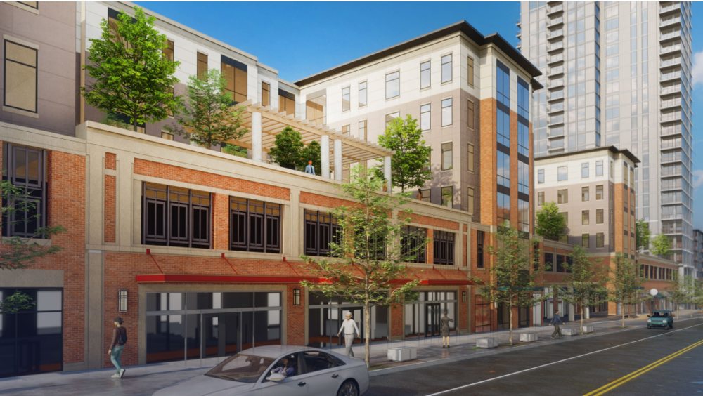
A couple of new PDFs were posted related to "The District" development. Streetscaping, floor plans, and new concept art: https://res.cloudinary.com/courbanize-production/image/upload/v1/information_plans/sjkyk07u9hiqqqi9sj3g https://res.cloudinary.com/courbanize-production/image/upload/v1/information_plans/kegxz4swo9jtuuc1mfhr

-
It probably doesn't help that Mt. Auburn has no real business district to walk to. Inwood Park though, that place is always deserted. I'd have thought it would have picked up some more activity from the new units. It's a pretty charming area.
-
https://www.zillow.com/homedetails/2352-Ravine-St-Cincinnati-OH-45219/2082251153_zpid/ Looks like this is speculative, but it includes a design for a "22-56 bedroom" apartment building going in on Ravine and Volkert where a church currently sits.
-
Yeah I did. That stop doesn't seem to show up in their Word doc listing all the Phase III removals, so hopefully the map is wrong.
-
According to that map, the 17 soutbound stop at Warner and Clifton is slated for removal. Not only does that seem weird because it's a fairly major intersection, but they also just installed a new bench there. And selfishly I'm annoyed because that's the closest stop to my house, and really the closest stop to a big porttion of western CUF, which already has terrible access as it is.
-
I agree with most of the sentiments already expressed - it was fun, but lost a bit of the magic from two years ago. Maybe that was due more to expectations than anything, but I agree that there was a feeling of being too spread out. I still thoroughly enjoyed it though, and the street closures made it really easy to zip around on a bike. One thought I had that might be cool for the next iteration would be to utilize some of the skyscrapers, especially the older ones like Carew and Central Trust. Imagine having a projection up at the top of one of those buildings - you'd be able to see it from almost anywhere in the vicinity, plus from up on the hills and across the river. It might help with the lull of some of those dead zones between installations and make feel the whole city seem more alive by pulling everything together and make it more cohesive.
-
Don't know if this is obvious by now, but the "AOC supporter" was a right-wing troll: https://www.snopes.com/fact-check/babies-climate-change-aoc/
-
Community leaders, developers work together to make Innovation Corridor car, pedestrian friendly: https://www.wcpo.com/news/transportation-development/move-up-cincinnati/community-leaders-developers-work-together-to-make-innovation-corridor-car-pedestrian-friendly Interesting discussion of how to make a 9-lane pseudo-highway less terrifying for pedestrians and cyclists.
-
This West End listing comes "with view of Central Pkwy." I'll let you be the judge if that view is worth it: https://www.zillow.com/homedetails/427-Whiteman-St-Cincinnati-OH-45214/34236640_zpid/?

-
If they end up next to the Baldwin building, they will be close to the recently proposed Art Museum steps (https://www.citybeat.com/arts-culture/visual-arts/blog/21066164/cincinnati-art-museum-is-building-an-art-climb-staircase-to-connect-with-community-activate-grounds). So while that stretch of Gilbert is currently cut off from things, the Art Museum will at least have more of a presence right across from the proposed Ballet location.
-
-
I remember reading somewhere that Taft/Calhoun and McMillan were turned one-way when the Bengals played a game in the late 60s at Nippert, and they just never reverted it. In any case it's nice to see them slowly converted back, one section at a time. I wonder what it will take to convert anything west of 71 through Corryville and CUF.
-
That rendering looks better than I was expecting. Looks like it will be a full 6 stories above Taft. That's one corner that I never expected to get developed. That little triangle actually has a bit of charm to it when coming south from Euclid, but most people just zoom through on Taft and don't notice it.
-
Also, don't forget the number of new hotels going in. I don't have a list right in front of me, but it seems like 3-4 are in the process of being developed with several more on the horizon. Not as great as permanent residents, but hotel guests often walk around the area, visit restaurants, etc, and generally add to the vibrancy of an area. It's also nice to have more smaller hotels spread out around the CBD vs the old school tower hotels clustered around the convention center.
-
The benefit of using Ravine is that it connects directly to the Central Parkway bike lane.
-
If the eBikes are better at handling Ravine and Clifton hills than the scooters (which barely handle them), they might become more popular with UC students going down to Over the Rhine. It's a very short ride, but most people aren't thrilled with the idea of biking back up the hill.
-
I went biking around Walnut Hills yesterday and came across this bizarre street that rises off of Florence Ave squished next to I-71. It starts as Boone St, and the sidewalk is more like a staircase: https://www.google.com/maps/@39.120108,-84.4967279,3a,75y,3.17h,93.39t/data=!3m6!1e1!3m4!1sNV1fFytqJsUnCSOa7icZBw!2e0!7i13312!8i6656 At the top of the hill it turns sharply to the left and becomes, for a couple dozen feet, Manitou St. There is a single house tucked away on Manitou St: https://www.google.com/maps/@39.1210314,-84.4967308,3a,75y,184.22h,80.26t/data=!3m6!1e1!3m4!1sCpCMr5zj-5o2CWjvQhoHxA!2e0!7i13312!8i6656 Then it continues around a baseball field as Terhune Alley until joining up with the Walnut Hills grid as Monroe St: https://www.google.com/maps/@39.1216447,-84.497053,3a,75y,52.48h,94.35t/data=!3m6!1e1!3m4!1sCnOyWeB28kdv9SCnbFXJGg!2e0!7i13312!8i6656 Then Boone St continues to the left off of Monroe all the way to McMillan. Seems like at some point they chopped the street apart to create the baseball field.
-
Both of these buildings have been renovated by Kunst. You can see photos on their site at the bottom under "Best & Lothes": http://www.kunst.us/apartments/ Anyway, nice photos. I love the part of McMicken that bends around Brighton Bridge. Nice views of the entire basin, trees, beautiful houses. It's the kind of street that seems to only exist in Cincinnati (maybe Pittsburgh has similar streets, I don't know).
-
https://nathanrooy.github.io/posts/2019-02-06/raspberry-pi-deep-learning-traffic-tracker/ Pretty fascinating, this guy independently created a device to track pedestrians and cyclists along Central Parkway using Rasberry Pi. Existing systems used to count traffic really only work for automobiles, so there's a big blind spot.
-
I drove down McMillan from Clifton Heights through most of Walnut Hills this morning. To my eye there is more development/redevelopment happening in the stretch between 71 and Victory Parkway than in any other part of the city right now. It's pretty cool to see. And that's even without the Anthem site moving along yet.
-
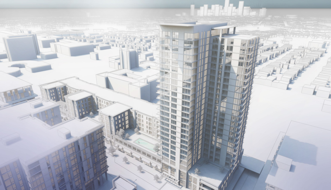
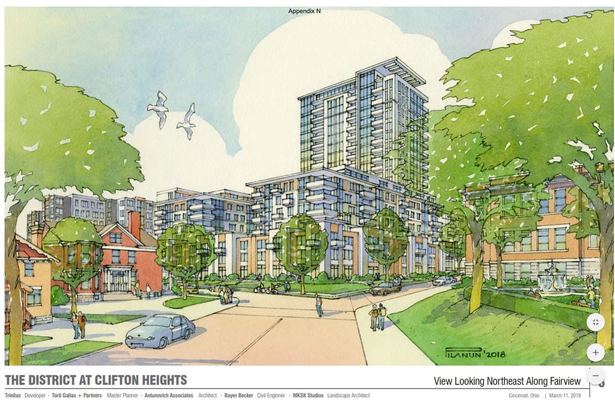
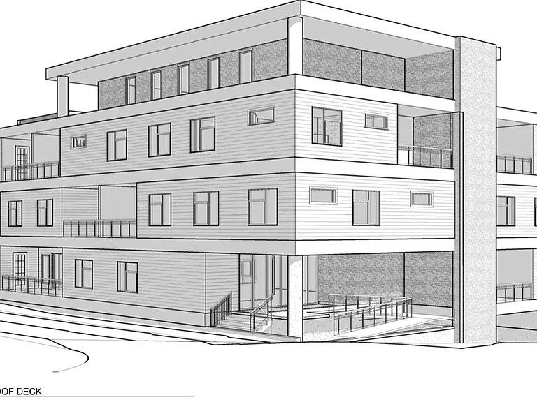
A bunch of documents are up on the city website related to this project: https://www.cincinnati-oh.gov/planning/planning-projects-studies/the-district-at-clifton-heights-zone-change/ I can't tell if there's much that's changed. Here's the latest renderings: https://www.cincinnati-oh.gov/planning/assets/File/The District - Appendix N.pdf It looks like maybe the residential development near the along Fairview grew a bit. I remember them looking more like townhouses previously.

-
It's my understanding that the lot is challenging due to the elevation change and rocky terrain. I think CHURC or whoever exactly owns the lots is holding out for a more upscale developer who would invest in partially underground parking, as opposed to the simpler option of a surface lot. They've spoken of trying to target a hotel and/or YP housing as opposed to more student housing.
-
Yeah, the dream would be to revitalize Camp Washington with Colerain being a lively business district like Hamilton in Northside. I'd love to ultimately see it get better connections to both CUF and Brighton/OTR. If those vacant lots near Marshall and Central Parkway ever get developed decently that would help it feel a little less cut off, and then similarly along the long strip of Harrison that connects to the West End and is currently a light industrial dead zone. But I think those scenarios are quite a ways off. I think the main challenge is the lack of decent single-family houses, which Northside has an abundance of. The street grid in Camp Washington is so chopped up by I-75 and Hopple. To increase the population of the neighborhood we'd really need to see some big apartment buildings, like the Crosely building, come online.
-
https://www.wcpo.com/news/transportation-development/move-up-cincinnati/camp-washington-will-soon-lose-one-of-two-beloved-chili-parlors Not sure if this was already known, but the US Chili building was sold "to the Camp Washington Community Board, a neighborhood community development corporation, and the Camp Washington Business Association." They have ambitions for a mixed-use redevelopment. So, thank God, no AutoZone.