jonoh81
Jeddah Tower 3,281'
-
Joined
-
Last visited
Everything posted by jonoh81
-
I'm not a big fan of their methodology. People in that age bracket don't just move to a place, they also grow up there naturally, and that population counts the same, IMO. There isn't some reason to think that Millennials that are from a specific city are wholly different than those that move there, so it makes more sense to me to show the overall change in population of that age group. It's millenniasl moving there minus the millennials leaving so it captures people who grow up somewhere and stay there. That would just be migration, not natural growth. I looked at the 2016 1-year estimates for mobility/migration and I haven't been able to find any combination that matches their numbers. There's not enough information to know what they used. BTW, here are the numbers for major Ohio cities 2005-2016 in terms of the total change in that age group, which would be the net of both migration and natural growth. 2005-2016 Akron: 0 Canton: -1,346 Cincinnati: +13,505 Cleveland: +11,519 Columbus: +55,851 Dayton: +8,053 Toledo: +264 Youngstown: -1,536 2010-2016 Akron: +1,462 Canton: -626 Cincinnati: +531 Cleveland: +6,673 Columbus: +21,084 Dayton: +4,680 Toledo: -2,268 Youngstown: -1,137
-
Doesn't who "counts" entirely depend on what you're trying to measure? If you're trying to measure where Millennials are moving, you don't count those who are staying in place. They don't actually say how they got those numbers other than saying from the Census and using 1-year ACS estimates, but not specifically which ones. They don't answer if this only included domestic movers rather than also international, for example. Also, even using ACS 1-year data, it only includes previous residences of those who moved TO a particular city, not those moving away, so it doesn't explain where they got those net numbers. There is no acknowledgement that the 20-34 population may not actually represent the Millennial population. The start and end year for that generation is not agreed upon, and some of the older fringe has already aged out of that range but would still otherwise be Millennials. So all they're really doing is showing the growth of that specific age group presumably only for domestic migration. It's not really a Millennial comparison.
-
I'm not a big fan of their methodology. People in that age bracket don't just move to a place, they also grow up there naturally, and that population counts the same, IMO. There isn't some reason to think that Millennials that are from a specific city are wholly different than those that move there, so it makes more sense to me to show the overall change in population of that age group.
-
The presence of the national park has nothing to do with why Cleveland-Akron isn’t a MSA. Furthermore, the area between the two cities along the I-271, SR8 and SR91 corridor has a decent amount of development (take a look at a satellite picture). SF-SJ, LA-Riverside have contiguous development between them but yet they aren’t MSAs. On the other hand Franklin County (Columbus) has two adjacent counties, Madison and Pickaway, that have no relationship in terms of development to Columbus but yet they are part of Columbus’ MSA. So the bottom line is that these MSA definitions have nothing to do with contiguous development. They have everything to do with politics and to a lesser extent, commuting patterns. And because there is so much overlap between the Cleveland and Akron areas in northern Summit and Portage counties and SE Cuyahoga County and southern Geauga County, the CSA would be a more accurate way of measuring the GDP. Using the MSA in THIS region just isn’t accurate. It’s a joke!! Why don't Madison and Pickaway have any connections to Columbus? Contiguous development isn't a standard used to add counties to metros, btw. Commuting patterns are one of the primary requirements. Politics only plays a role if one county elects not to agree to be added to a metro. So if there aren't combinations happening even with all other criteria being met, you'd only have your own regions to blame for that. So if there is obvious overlap and all the Census standards are being met, it would seem that maybe Akron doesn't want to be with Cleveland or Cleveland doesn't want to be with Akron. Same with Dayton and Cincinnati if that's the case. This is why I raised the question about regional cooperation.
-
Serious question... is there much indication that the region would work together better than the city does with its suburbs? Aren't you just assuming that Akron is going to have the same interests as Cleveland, and that they're going to be willing to put their own best interests aside for the good of the greater region? That seems unlikely. Same with Cincinnati, which has a notoriously bad relationship with its suburbs. I'm not sure throwing Dayton on top makes it better. The only thing that would change is perhaps federal funds. Serious question... is there much indication that the region would work together better than the city does with its suburbs? Aren't you just assuming that Akron is going to have the same interests as Cleveland, and that they're going to be willing to put their own best interests aside for the good of the greater region? That seems unlikely. Same with Cincinnati, which has a notoriously bad relationship with its suburbs. I'm not sure throwing Dayton on top makes it better. The only thing that would change is perhaps federal funds. Benefits of combined MSA A combined MSA would boost the Cincinnati-Dayton region into the top 20 largest metropolitan areas in the country. According to the 2015 estimates, Cincinnati’s MSA ranks 28th in the United States and boasts a population of nearly 2.2 million across 15 counties in Ohio, Kentucky and Indiana. Dayton is smaller with a total estimated population of 800,909 in four counties. If the MSAs are combined, the area will reach a population of approximately 3 million and rank 19th in the country. These statistics are important because they make the southwest Ohio region more attractive to companies looking to locate in a large city, especially if those companies want a more affordable area than metros like New York, Los Angeles or Chicago. A larger workforce, access to more universities, and other benefits are key to winning larger bids and attracting more business to southwest Ohio. Heightened interest in the region will increase the volume and velocity of commercial real estate in the marketplace. http://rebusinessonline.com/cincinnati-dayton-closing-the-gap-why-the-push-to-merge-the-msas-is-a-winning-strategy/ That didn't answer my question. I'm asking if simply piling on more cities would actively encourage a regional strategy. Would Akron really care about helping Cleveland if it was in the same metro? Or vice versa?
-
Serious question... is there much indication that the region would work together better than the city does with its suburbs? Aren't you just assuming that Akron is going to have the same interests as Cleveland, and that they're going to be willing to put their own best interests aside for the good of the greater region? That seems unlikely. Same with Cincinnati, which has a notoriously bad relationship with its suburbs. I'm not sure throwing Dayton on top makes it better. The only thing that would change is perhaps federal funds.
-
No idea what the accuracy of these numbers are, as the BEA hasn't released metro totals for 2017 yet. If they are, the 2016-2017 change for the 3-Cs would be something like: Cincinnati: +$5.6 billion Cleveland: +$4.5 billion Columbus: +$6.5 billion And the supposed 2018 estimate/projection Top 10: 1. Chicago: 703.9 2. Detroit: 274.2 3. Minneapolis: 268.3 4. St. Louis: 168.0 5. Indianapolis: 149.7 6. Cincinnati: 143.9 7. Columbus: 143.9 8. Cleveland: 139.9 9. Kansas City: 138.9 10. Milwaukee: 110.5
-
I know it's on the Amazon top 20 list, which seems like the most relevant list to be on. We're in the final 10... geographically(among other reasons) it makes sense, but I'm not going through that all over again. When was the list narrowed down to 10?
-
CC isn't really a bust IMO. What was disappointing was the scale/design of the individual projects approved by the Downtown Commission, but the overall project has worked pretty well. I am okay with developing the Peninsula on a piece by piece basis so long as they have a general foundation for what they want it to look like, hopefully without height restrictions or demands that everything look like a brick box. We don't need another Arena District development. So in that way, I'm very glad Buckingham is out. Their plan was too short and way too bland, and perhaps one of the reasons they're out is that the choice received a lot of criticism in that regard. At least involving multiple developers means we should see more of a mix of styles, which would be okay with how Franklinton already is. That said, waiting for the Amazon announcement seems silly to me unless they know something we don't. Love Columbus and all, but it's on no one's list of likely choices for that project. Have they heard differently or are just hoping?
-
The variety of businesses in the Short North hasn't really changed. A few galleries closing doesn't mean there aren't galleries to walk to, nor does it mean that no new types of businesses have opened. I think this is just a debate in futility and semantics. The scores are far from perfect. Another example of their imperfection is using population data at the tract level. Up until I think last year, the Census had the Short North losing population, which would affect the score also. Does that also seem reasonable?
-
I think the walk scores are illuminating to this conversation. You can have a density of residents over a large area, but if there aren't many businesses in that area, what is the point? The primary reason urbanists like density is it enables walkable neighborhoods. Maybe what's going on here is that the older C's have a greater mix of uses. Anecdotally, that makes sense from what I have seen of Columbus; that the retail/commercial districts are more segregated from residential districts (versus Cleveland/Cincinnati). You also see that in edale's streetviews. In edale's more-urban examples, you see a mix of uses. In the others, you don't. People give too much credence to this site. The last time I looked at it, it showed the walkscores had dropped for pretty much the entire High Street corridor and neighborhoods, including the Short North (however it is defined). Does anyone really believe that walkability declined there? Yet Walkscore said it did. People should take these scores with a HUGE grain of salt. The constant creep away from stores that sell objects to having more and more bars and restaurants will negatively impact walkscores. I'm not sure how going from more galleries to more restaurants would negatively affect walkscores. More people eat than buy art. The clothing stores have largely remained. Other than that, what's really changed significantly?
-
It makes sense that the city is High Street focused. That's where most of its best urban neighborhoods are, from Worthington to Campus south to Merion Village. And that's a huge, continuous area, longer and larger than in almost any comparably-sized city. That said, West Broad is going to explode soon, at least in Franklinton. And all of the Near East neighborhoods are rapidly improving. The Parsons Corridor is seeing a lot of new stuff and places like Old Oaks have seen their vacancy rates plummet. Summit/4th are already well on their way, with multiple projects under construction or about to begin. The entirety of Weinland Park is getting better too. 5thxNW. It's really not that hard to find areas off High seeing action.
-
I think the walk scores are illuminating to this conversation. You can have a density of residents over a large area, but if there aren't many businesses in that area, what is the point? The primary reason urbanists like density is it enables walkable neighborhoods. Maybe what's going on here is that the older C's have a greater mix of uses. Anecdotally, that makes sense from what I have seen of Columbus; that the retail/commercial districts are more segregated from residential districts (versus Cleveland/Cincinnati). You also see that in edale's streetviews. In edale's more-urban examples, you see a mix of uses. In the others, you don't. People give too much credence to this site. The last time I looked at it, it showed the walkscores had dropped for pretty much the entire High Street corridor and neighborhoods, including the Short North (however it is defined). Does anyone really believe that walkability declined there? Yet Walkscore said it did. People should take these scores with a HUGE grain of salt.
-
jonoh81 replied to buildingcincinnati's post in a topic in Central & Southeast Ohio Projects & ConstructionTrue, the road is not exactly friendly to anything, but they did add that multi-use path not that long ago. There's not even really a connection to that, and it's directly in front of the property. I mean, come on.
-
jonoh81 replied to buildingcincinnati's post in a topic in Central & Southeast Ohio Projects & ConstructionFor comparison, here is the current layout. This is such a weird project. On one hand they are adding a much larger, much more urban-designed building, but on the other, they're keeping just as much parking as before, and the way it's setup, it's just like a much larger strip mall than before. There is zero street interaction with any of the nearby roads and is incredibly unfriendly to anything but cars. There's nothing really that makes this attractive to the potential residents, IMO. Where are they going to go? I guess this is not surprising considering Don Casto Sr. was one of the original creators of the strip mall, so they're sticking with what they know. I suppose they could build on some of that surface parking at a later date, but as it stands, it's another letdown for me personally. Columbus desperately needs some serious urban developers.
-
Think outside the box a bit, warehouses equal jobs and an economic boost to a neighborhood that sure could use it. There's a lot of development that could go there that would give the area an economic boost. Pretty much anything but a vacant lot would. I just think warehouses are squarely inside the box, personally. It can be re-purposed/developed quicker as warehouses; otherwise it would be a greenfield development aka more money and years of red tape. The environmental issues have to be remedied before any development anyway, so I'm not sure I buy that. I'd rather see it done right and maximize the site's potential than build something just to have something there.
-
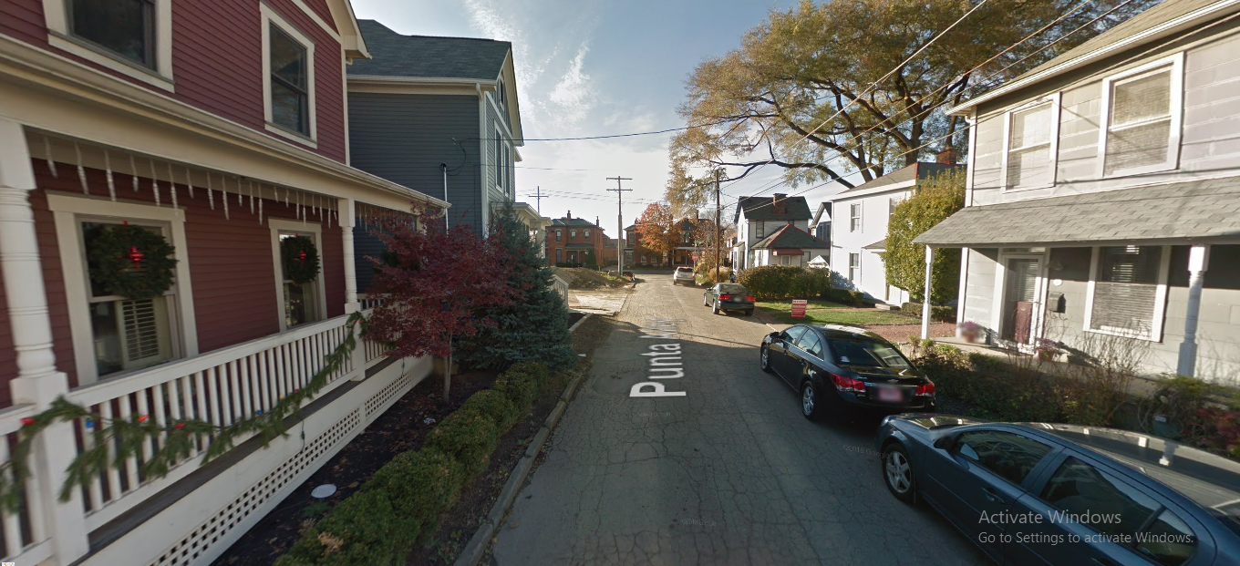
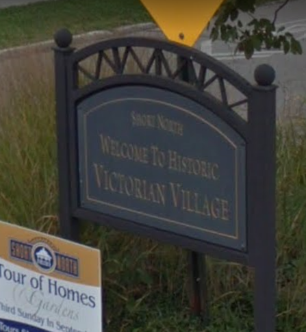
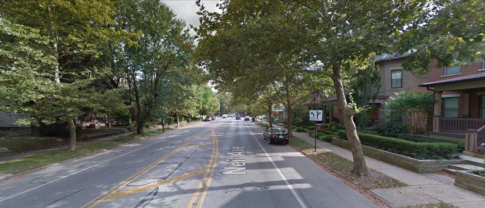
So you guys are telling me the 2 main neighborhoods making up the Short North... are not in the Short North? K. There are these signs all over the area. I could only find a picture of this one, but I know they exist in Italian Village also. I also think that even Harrison West and The Circles also have signs like this that say "Short North" on them. Again, the High Street corridor may be thought of as the heart of the Short North, and it is, but that's not all of it. It was originally the entire area just north of Downtown south of 5th, several blocks on either side of High. Italian Village is the east side of High, Victorian Village on the west side. Why do you guys think that both neighborhoods have development commissions that have a direct say in development along High Street? Even the Short North Block Watch includes 6 different areas- High Street, Vic Village, Italian Village, The Circles, Harrison West and Dennison Place. Yea, others have addressed this already but parts of Victorian Village and Italian Village are in the Short North, which was an informal term originally used disparagingly to refer to the stretch of High Street just north of downtown. Go to Google Maps and type in all three and it'll show you the boundaries. But you're right that many people use the term to refer to different things. That's why I stated that neighborhood boundaries are semi-arbitrary anyway. Actually it seems everyone has said a different thing. The people that actually live there know where they live, they put in on their neighborhood signs, its on their websites... but what do they know. No, nothing said has been inconsistent. It is a Venn diagram, like jmecklenborg pointed out. Short North is the mixed-use area along High Street, extending one block in each direction. Victorian and Italian Villages are residential neighborhoods to the west and east of High, but they overlap with the Short North area. Now that Short North is trendy it's popular for people to use that term for a much larger area, but it hasn't been traditionally used that way. For example, I have a friend that lives in The Circles. He tells people Short North because they know it and they don't know what The Circles is half the time. The Circles are traditionally not part of the Short North since they are north of 5th. The civic association and block watch groups for all these nearby neighborhoods call themselves Short North because it's popular, that's all. How can a neighborhood overlap with another, but not be part of it again? That just seems like semantics to me. Perhaps the definition of what makes up the Short North is not the same as it once was, but it's always been more than just High Street. There's never been an imaginary line that separated parts of the Villages away from the other parts. That's pretty much the last I'm going to debate this, as it seems the only thing we're going to agree on is that 5th has always been the northern extent.
-
Think outside the box a bit, warehouses equal jobs and an economic boost to a neighborhood that sure could use it. There's a lot of development that could go there that would give the area an economic boost. Pretty much anything but a vacant lot would. I just think warehouses are squarely inside the box, personally.
-
So you guys are telling me the 2 main neighborhoods making up the Short North... are not in the Short North? K. There are these signs all over the area. I could only find a picture of this one, but I know they exist in Italian Village also. I also think that even Harrison West and The Circles also have signs like this that say "Short North" on them. Again, the High Street corridor may be thought of as the heart of the Short North, and it is, but that's not all of it. It was originally the entire area just north of Downtown south of 5th, several blocks on either side of High. Italian Village is the east side of High, Victorian Village on the west side. Why do you guys think that both neighborhoods have development commissions that have a direct say in development along High Street? Even the Short North Block Watch includes 6 different areas- High Street, Vic Village, Italian Village, The Circles, Harrison West and Dennison Place. Yea, others have addressed this already but parts of Victorian Village and Italian Village are in the Short North, which was an informal term originally used disparagingly to refer to the stretch of High Street just north of downtown. Go to Google Maps and type in all three and it'll show you the boundaries. But you're right that many people use the term to refer to different things. That's why I stated that neighborhood boundaries are semi-arbitrary anyway. Actually it seems everyone has said a different thing. The people that actually live there know where they live, they put in on their neighborhood signs, its on their websites... but what do they know.
-
Victorian Village and Italian Village are both part of the Short North and have been considered so as long as I've known. Even the signs entering the neighborhood say "Short North" on them. It couldn't just be High Street because one side is literally in Victorian Village and the other is literally in Italian Village. Many people will say "Short North" when they are referring to either the Victorian Village neighborhood or the Italian Village neighborhood on either side of High Street between downtown and 5th Avenue. Sometimes they are referring to the High Street corridor that is the densest, busiest and most-visited part of the "Short North" area. The way we've ended up describing here it at Urban Ohio (in the projects threads) is as follows: 1) Short North - The High Street corridor between downtown and 5th Avenue that contains much of the commercial activity in the area. 2) Victorian Village - The primarily residential neighborhood west of High Street between DT & 5th 3) Italian Village - The primarily residential neighborhood east of High Street between DT & 5th The separation of development threads makes sense from that perspective just because so much is happening there, but yeah, almost everyone today that lives there would say that they live in the Short North, regardless of what side of High.
-
So you guys are telling me the 2 main neighborhoods making up the Short North... are not in the Short North? K. There are these signs all over the area. I could only find a picture of this one, but I know they exist in Italian Village also. I also think that even Harrison West and The Circles also have signs like this that say "Short North" on them. Again, the High Street corridor may be thought of as the heart of the Short North, and it is, but that's not all of it. It was originally the entire area just north of Downtown south of 5th, several blocks on either side of High. Italian Village is the east side of High, Victorian Village on the west side. Why do you guys think that both neighborhoods have development commissions that have a direct say in development along High Street? Even the Short North Block Watch includes 6 different areas- High Street, Vic Village, Italian Village, The Circles, Harrison West and Dennison Place.
-
Victorian Village and Italian Village are both part of the Short North and have been considered so as long as I've known. Even the signs entering the neighborhood say "Short North" on them. It couldn't just be High Street because one side is literally in Victorian Village and the other is literally in Italian Village.
-
Meh, call me crazy but I'm just not that excited about that site becoming a bunch of warehouses. I understand the logic behind it, I just think it has so much more potential.
-
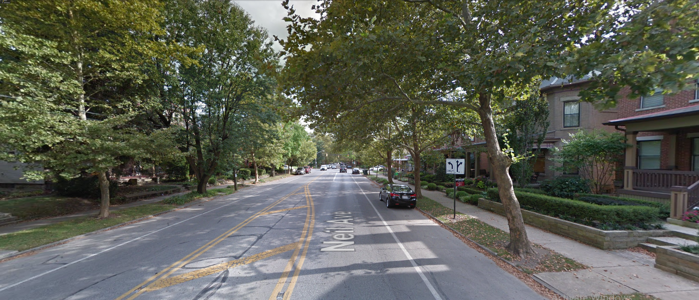
I'm okay with most of what you're saying, but I think we need to differentiate between building density and population density. Building density is probably what is causing most, if not all, of the perception issues- the "how a city feels" thing. If you have 10,000 density in a neighborhood that has thickly-spaced, old-school tenement housing vs. 10,000 density in a neighborhood largely with single-family homes and newer apartments, the only difference is perception. The activity on the ground would otherwise be exactly the same, right? Beyond the commercial corridor on High, the Short North is overwhelmingly made up of single-family homes. All of the below are taken from the Short North. All very different looks and feels. If you didn't know where they were, would you imagine they'd all be in the same urban neighborhood? Or would you suggest, only based on perception and building density, that the 1st and 3rd were not consistent with urbanity or density?

-
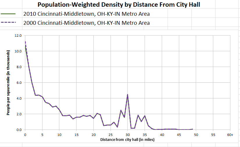
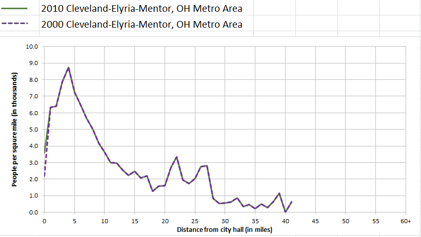
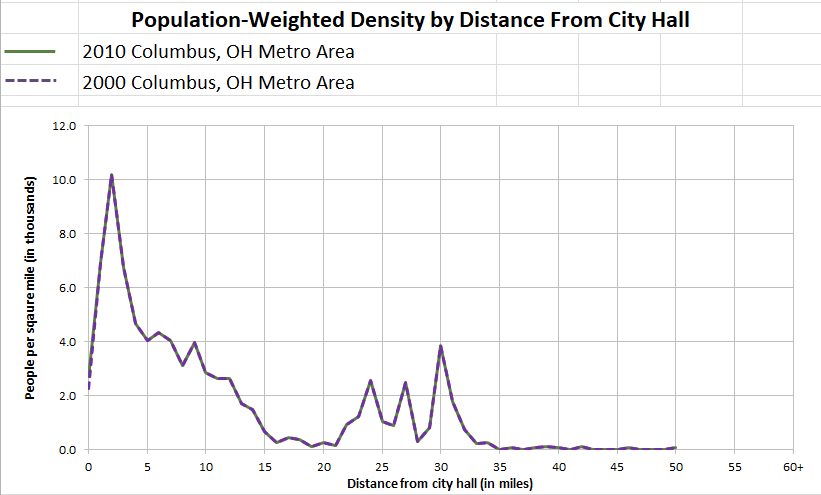
ANYWAY... In an effort to get the conversation back on track... here were the tract densities of the photos posted earlier. Tract 7551 out by Easton- newer single-family homes and apartments: 8,814.5 Tract 330 in North Linden- mid-century bungalows mostly, no apartments: 7,615.4 Tract 1121- OSU main campus: 27,477.8 Tract 6393- single-family homes on the Delaware County border: 6,110.3 Tract 55- historic neighborhood on the South Side: 7,790.8 Tract 8132- mixed development on the western border: 7,556.5 Tract 8822- mixed development- and a huge quarry- on the far south side: 1,960.1 I think what this illustrates more than anything is that densities in Columbus are a lot more standard across the city from edge to edge, with both lows and highs mixed in. It also shows that location relative to the core is less important in Columbus than what may be true in other cities, as it has higher densities even to the very edge of the city. I doubt most people would think that, and certainly not perceive it, which is a good reason to not rely on bias to make a point. Furthermore, population-weighted density was brought up before as a better measurement. I do have them for metros, which are going to be less detailed than wanted, but it's the only thing I have at the moment. The numbers are for 2010, so a little outdated, but... make what you will with them. From my view, a few takeaways... -Columbus is easily the most compact metro, with a lot more of its population closer to the core city than the other 2. -Cincinnati had the most dense CBD. -Cleveland had the slowest decline of density moving out from the core.