greenville2
Dirt Lot 0'
-
Joined
-
Last visited
-
Est. Const. Cost: $1,400,000,000 Begin Construction: Summer 2010 End Construction: TBD Could you imagine the outrage if this was a rail or transit project?
-
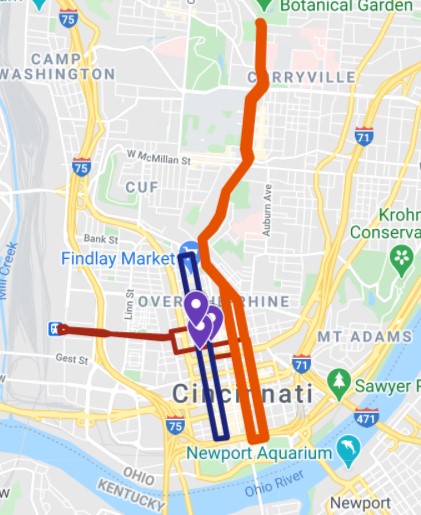
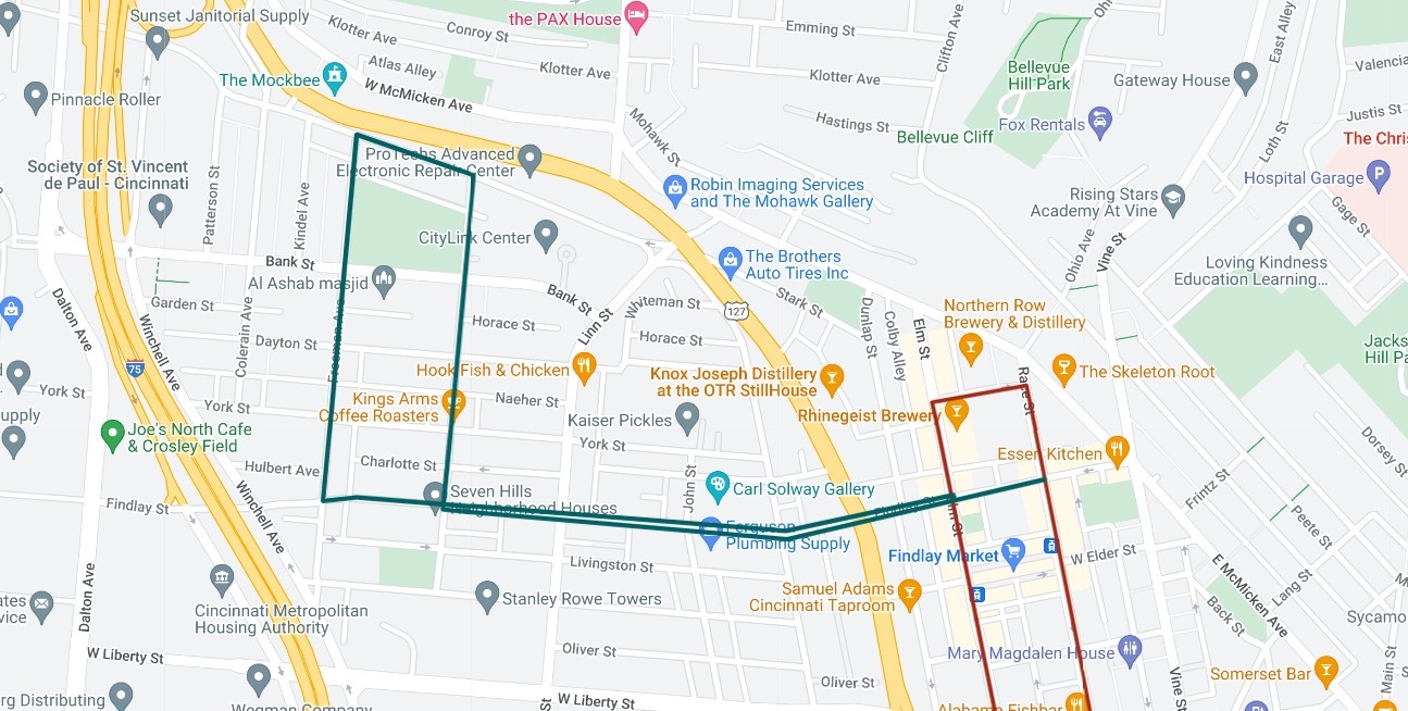
Driving through the upper part of the West End/Brighton, I am struck by the amount of potential there is in that area. A lot of historic building stock left, and lots of empty lots. The architecture is really something, too. As the primary aim of the Streetcar is to drive redevelopment, why not really cover that area with a streetcar extension right through the middle of it? This covers it a lot better than just going up McMicken. It would be a pretty "cheap" and simple project, too. About 2 miles of track in a flat area, on back streets. The only tricky part would be the switches at Elm and Race.
-
Caught a Reds game while I was in town yesterday, and the streetcar was standing room only throughout the part of the day I was in the area. As soon as the Reds fans filtered out of the area, the FC Cincinnati fans descended. And making it free was genius, not because the $1 matters, but because of the convenience. Makes it a no brainer to jump on if it is coming past while you are near a stop. The ticket machines were terribly slow.
-
I spend 10+ months of the year in Europe. I spend 1-2 months a year in Ohio. I don't own a car in Europe. I have to keep and maintain a car in Ohio for the time I spend there.
-
What is also interesting...whenever I scan satellite images to choose a good place for a stop for the 3C+D, there is almost always an historical/former stop there. Examples: Cincinnati - (Union Terminal) Hamilton - https://www.google.com/maps/@39.3942025,-84.558986,186m/data=!3m1!1e3 Middletown - https://www.google.com/maps/@39.5138846,-84.3921503,320m/data=!3m1!1e3 Miamisburg - https://www.google.com/maps/@39.6421063,-84.2845586,167m/data=!3m1!1e3 Dayton - https://www.google.com/maps/@39.7545381,-84.1936146,500m/data=!3m1!1e3 Gallion - https://www.google.com/maps/@40.7345637,-82.7834584,563m/data=!3m1!1e3 Or on a potential CMH-CHI Line Lima - https://www.google.com/maps/@40.7449926,-84.1012708,279m/data=!3m1!1e3 So it's not only been done other places before, but right in Ohio. 150 years ago.
-
I sit here in Poland, about 1/2 mile from a train station with 450 departures per day. Yet it is somehow it is impractical or even impossible for the US, with 4-5 times the GDP per capita, to manage serve a single station with 3 trains a day. In a metro twice as big as the one I am in. And getting people to and from the station is also a complex and insurmountable problem to be solved. Like...just do it. It's basic stuff for countries all over the world.
-
I don't know what rail is there, but why not close that gap to Atlanta? Make 2 longer routes there: 1 - Atlanta-Nashville-Louisville-Indy-Chicago 2 - Atlanta-Nashville-Louisville-Cincy-Columbus-Detroit
-
Well, I kick around moving back to Ohio sometimes. But it looks like this young professional will be staying away and working and paying taxes elsewhere for a while. Thanks for nothing, Ohio.
-
I lived in HH for a bit recently (what a dump), and while the south side is struggling a bit, the north side is typically sprawling. Lots of those suburban apartment complexes going up around 201/70, plus the typical cul-de-sacs. Anecdotally, it also seems to absorb Dayton residents in areas like Old North Dayton and the like moving up the social ladder a bit. Like the Ahiska Turks seem to be migrating north a bit, for example. No data to support the last two claims.
-
^ Thanks for the timetable and response. I know it's from 11 years ago, but I was pretty close to what they were proposing. Seems like today would be similar as well. Also, I know it's a mock timetable from 11 years ago, but it really makes you dream to see Ohio cities/towns on a train schedule.
-
Rode the streetcar for the first time in well over year the other day. I know it was only $2, but making it free really made it a no brainer to use for so many more trips. Used it to go to a day game at GAPB. But, for example, when you have 4 people, that's $8. So it starts to make more sense pay to park by the ballpark rather than park to the north and streetcar down like I did. Or you might walk from 2nd to Coffee Emporium rather than deal with a ticket. Not to mention that the machines were the slowest and worse machines I have used on any system. But for free? It makes so much sense to hop on and off all over the core. I mean, it made sense before at $2, but now it's a no brainer. And it was well patronized in the middle of a weekday. There were some older folks visiting downtown and clearly taking it for the first time. It seemed like an enjoyable experience for them.
-
I wonder what the timetable would look like for the 3 trains. Departing from the termini at roughly 7am, 1pm, and 5pm perhaps?
-
The Las Vegas loop is super dumb. All of this tunnel boring to drive...cars...through it. A claimed top speed of 155 miles per hour is pretty laughable to considering it goes between a convention center and a parking lot. I think I have seen horizontal wheels like these that keep a vehicle inside a track before...maybe on one of the log rides at Kings Island? LOL, autonomous vehicles...
-
Who on earth signed-off on a mass people moving system literally comprised of people driving passengers between stations in cars over the dozens of more efficient options used everyday in cities and airports around the country and the world?
-
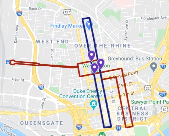
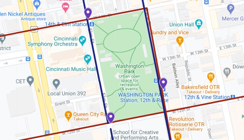
A casino to Union Terminal line doesn't seem all that useful and it's hard to see how that would work with the current system well. A "branch" to UT that operates as a second line makes some sense (Banks to UT and Banks to Findlay would be two lines that share track downtown). Or, even better would be an extension west to UT and one South to Paul Brown Stadium Area. So there would be two lines: Banks to UT and 3rd St. to Findlay (clockwise loop). Transfers would be possible at stations around Washington Park. Allows both sides of downtown to be served, makes future extensions to Covington easy. You could extend north from Findlay Market or even north on Main/Walnut to Vine (so there would be a 3rd line from Banks to Uptown that doesn't snake around. )