
GISguy
One World Trade Center 1,776'
-
Joined
-
Last visited
Everything posted by GISguy
-
 lol missing the murals though :( But one of the Public Works guys was like oh yeah, that big ol conduit carries power to xyz neighborhoods, that there's telecom for x and y - pretty much when they closed it down it turned into a big infrastructure opportunity.
 -
I know they'll secure it, but there's a LOT of very important infrastructure under there. I worked last bridge tour and it was interesting learning about what all is under there...
-
Not the most artistic photos (mid bike) but here's some updates of Centrovilla:
-
Inspired a lunch walk down there (side note, they're also jackhammering the stadium ramps right now).
-
TBH it looks like this is what we were getting into. Just looks more disappointing in reality haha Question is: how often will it be open? The concessions upstairs are barely open as is.
-
Phew, I had no idea what the place was called. Not like there wasn't a HUGE sign above it. I kid, but the added PROGRESSIVE ads that were in the renderings are going to be a lot.
-
Great turnout last night. I think it's obvious that folks want to see things now and Jacob w/BC did a great job of highlighting how quick and simple changes would improve the city drastically vs only relying on huge transformational projects like the midway/lorain. One thing I really loved was him suggesting Leading Pedestrian Intervals at Cleveland street crossings - I've only noticed this at E. 9 in front of the county building, at this point it seems pretty standard in other cities. Here's Channel 19 coverage: https://www.cleveland19.com/video/2024/03/06/city-cleveland-bike-cleveland-city-club-hold-forum-discuss-pedestrian-bike-safety/ And the full forum:
-
I think people are overestimating the financial stability of CDC's. Even though it's one of the hottest neighborhoods in town OCI isn't exactly floating in cash: https://projects.propublica.org/nonprofits/organizations/341372076 to be able to float super low rent rates/maintain buildings for eternity.
-
Catching up to this thread, but the scene from 'dogs day in cleveland' ad from Destination Cleveland also used an outdated drone shot for the closing scene.

-
Side note, as these formerly industrial areas get built up they've got to get some ladders and life rings on the bulkheads. Poking my head out in and around down there I can't help but think if someone fell in it'd be bad news. Thankfully the UO mods said I'd be compensated for pain and suffering if I fell in but that's besides the point. And I know there's a better place for this link, but years ago I made a map of all the Cleveland breweries I could dig up (it goes back a page of comments, but yes, a ton were in residential hoods, but Cleveland was also a very different city back then): https://veganbrisket.maps.arcgis.com/apps/webappviewer/index.html?id=19628b56e7f8479c9261b7700272616c
-
Was going to post a bunch of photos I took last night but it hasn't changed much since some of the other (better) photos in here.
-
From last week (from the Metroparks' newly acquired Grain Craft Flour Site): Bonus looking towards the city:
-
Photo dump... From last week: And from yesterday in the Industrial Valley: Adding a couple more from lunch today:
-
Not related to Hopkins, but those lights coincide with all the lighthouses on the Great Lakes when viewed from the right angle...pretty sure that's what a fellow GIS nerd told me!! Edit: Ope, it's major cities/population centers, either way really cool. Honestly if it were lighthouses there'd be a LOT more lights...
-
Their homecoming fest in cinci was really awesome. I'm honestly not a huge fan of the festival idea because a lot of the time it's too hodgepodgy with the genres and stuff but the folks in the National curated such a good set of related artists it was like playing 'The National Radio' on spotify or something. It'll be a great show, I'd totally recommend being inside vs lawn for this one.
-
FYI, the Ballpark Pass is back this year, just signed up today. Poor man's season tickets...nice to have the ability to stay or leave depending how the game's going! Also day games make for a nice lunch break...
-
They've added the flexposts to Det-Sup bridge, last Friday they completed them down to the 'mixing zone' with cars. I guess that's one "people over cars" initiative completed. Posts aren't going to save you when a car veers into the lane going the typical 40-45 on this bridge. Hate to always be so negative in the twitterverse but man do things take a million years in this town (they said this project was going to be completed ~December).
-
~30th and Community College Wanted to take a pic coming down Kinsman from ~93rd but biking that section isn't the most chill, so if someone decides to go to the McDonalds with the best view, snap a pic! It's a really nice angle of the downtown.
-
I recall going into Corner Alley just to hang out and grab a brew, bartender warned me of 'ASG' prices. Not quite NYC or LA but appreciated the warning... Imagine getting a $42 growler of Miller Lite lol It was certainly an experience (hearing someone explain you got to choose a flight at a brewery to the LA crowd's amazement, hearing folks talk about how 'cheap' it was, and so on was interesting), but that's for another discussion lol Long story short, had more places gouged, it probably would've been even higher.
-
I know it'd add a huge expense and it isn't realistic to keep it, but bummer that nearly every plan that comes out includes the demo of the old juvie building.
-
Just gotta say, I appreciate you putting the time into this thread @mrnyc!
-
Great news, that's a cool building!
-
My department is hiring, application deadline is 3/1/24. Link. GIS Analyst - 1541 Posted 3 days ago | Apply before March 1, 2024 US:OH:Cleveland | Information Technology | Full-Time (Benefits Eligible) 65,000.00-78,020.80 USD Description Department: Information Technology (IT) Anticipated Work Schedule: Monday-Friday 8:30am-4:30pm, flexible Reports To: GIS Applications Administrator Full Time or Part Time: Full Time Regular or Temporary: Regular Bargaining Unit: Non-bargaining Classified or Unclassified: Classified FLSA: Exempt Summary he purpose of this classification is to assist with administration of the Geographic Information System (GIS) environment including the design and update of GIS data and the design and development of GIS applications and dashboards to solve problems using data modeling and spatial analysis. Distinguishing Characteristics This is a journey level classification in the GIS series responsible for the integrity of GIS data and for the development of GIS applications and dashboards. Employees at this level work under general supervision from a unit manager. Employees are expected to work independently and exercise judgment and initiative. Positions at this level receive instruction or assistance as needed and are expected to become up to date on the methods, operating procedures, and policies of the work unit. This classification is distinguished from GIS Technician where this classification is responsible for more complex GIS analyses. Essential Job Functions The following duties are normal for this classification. These are not to be construed as exclusive or all-inclusive. Other duties may be required and assigned. Designs, refines, and updates GIS data, databases and metadata; collects and interprets GIS data (e.g., tax maps, legal centerlines of streets, collected field data) to update databases; cleans data and monitors health and performance of databases; designs and maintains spatial GIS models; performs database querying; develops requirements, specifications and diagrams for the GIS infrastructure. Designs, develops, deploys, and tests GIS web applications and dashboards; determines clients’ GIS needs; writes queries to pull information for the application or dashboard; creates mapviewer applications, interactive graphs, and interactive charts; uses various software to create applications creates user accounts and passwords for client access to applications or dashboards; updates actions as needed. Provides other software assistance; coordinates public and County GIS data sharing and exchange; designs and develops reports; designs and maintains desktop databases for reports and maps; provides training to lower-level employees and end-users. Administers GIS databases; deploys and administers GIS applications, server software, middleware, and licensing; create backups; manages database security and user access. Minimum Requirements Bachelor’s degree in information technology or related field and three (3) years of GIS analysis, development, or computer programming experience; or an equivalent combination of education, training, and experience. Additional Requirements Ability to operate a variety of automated office machines including personal computer, printer, plotter, GPS equipment, mobile devices, and drafting tools. Ability to operate a variety of software and databases including GIS software (ArcGIS), image editing software (GIMP), spreadsheet software (Microsoft Excel), database software (Microsoft SQL server Studio), and word processing software (Microsoft Word, Nitro). Ability to add, subtract, multiply, divide, calculate decimals and percentages, and make use of the principles of algebra, geometry and descriptive and inferential statistics. Requires the ability to perform mid-level data analysis including the ability to audit, deduce, assess, conclude, and appraise. Requires discretion in determining and referencing such to established criteria to define consequences and develop alternatives. Ability to comprehend a variety of informational documents including external GIS data, external assessment data, maintenance data, maps, schematics, design record drawings, CAD files, image files, fiscal records, property deeds, and other reports and records. Ability to comprehend a variety of reference books and manuals including database documentation, development documentation, server documentation, Ohio Revised Code, departmental guidelines, and computer software manuals. Ability to prepare GIS data, analysis reports, office application data, map reports, map deliverables, assessment estimates, application reports, annual report and other job-related documents using prescribed format and conforming to all rules of punctuation, grammar, diction, and style. Ability to convince and influence others, to record and deliver information, to explain procedures, and to follow instructions. Ability to use and interpret GIS data modeling, database and web development syntax, and statistical analysis terminology. Ability to communicate with managers, supervisors, vendors, consultants, other County employees, and the general public. Application Process This is a competitive, classified position. The Personnel Review Commission (PRC) will check your application to make sure you meet the minimum qualifications. If you do, the PRC will invite you to take a civil service examination. The exam is specific to this position. Everyone who passes the exam goes on an eligibility list. To fill this opening, the PRC sends the hiring department and Human Resources (HR) a certified eligibility list with the top 25% candidates (or at least the ten highest scoring candidates, whichever is greater). HR helps the hiring department decide who from the certified list to follow up with for interviews and then a job offer. Most of our communication with candidates is through email. Regularly check the email address you gave us in your job profile. Watch your Spam folder, just in case. If we offer you a job, you must pass a drug screen and background check before the offer becomes final. Prior criminal convictions do not automatically disqualify you from employment; the County looks at criminal convictions on a case-by-case basis using the guidelines in Chapter 306 of the County Code. EQUAL OPPORTUNITY EMPLOYER Cuyahoga County is committed to fostering a diverse and inclusive workforce, which includes building an environment that respects the individual, promotes innovation and offers opportunities for all employees to develop to their full potential. A diverse workforce helps the County realize its full potential. The County benefits from the creativity and innovation that results when people with different experiences, perspectives, and cultural backgrounds work together. The County is committed to providing equal employment opportunities for all individuals regardless of race, color, ancestry, national origin, language, religion, citizenship status, sex, age, marital status, sexual preference or orientation, gender identity/expression, military/veteran status, disability, genetic information, membership in a collective bargaining unit, status with regard to public assistance, or political affiliation. If you need assistance applying or participating in any part of the candidate experience, contact Human Resources at 216-443-7190 and ask to speak with a talent acquisition team member.
-
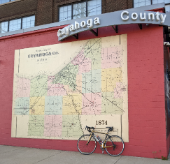
Biking home the other night:
-


