
Smaug_Puck
Dirt Lot 0'
-
Joined
-
Last visited
Everything posted by Smaug_Puck
-
I guess both, because there must have been kind of economic calculation/estimation on how many trains would be needed for a certain service level.
-
Re the number of trains being bought and what frequency that would allow, does anyone know what availability is expected from the new rolling stock? 75%, 90% or something else?
-
@NorthShore64 Some questions: In your plan, there are no new infrastructure in the form of new track, but what about station infrastructure? I can imagine if for example the waterfront line terminus had stairs/ramps/elevators to a footbridge connectiing it better to both the airport and downtwon how patronage on the waterfront line might increase. Likewise on both the western and eastern parts of the system infill stations might be more viable with denser service and TOD. For example 2 new stations between West Bouleward and Ohio city, a station at the basketball and baseball stadiums and between East 79 and east 105? As the system have been expanded in steps and thus trains can reverse at platform at some stations, would it be possible, if money is an issue that during regular offpeak times some of the services reverses at not the terminuses, for example the Orange line could be between Tower city center and Little italy at off peak?
-
@E Rocc and @KJP , my bad I was looking at this page https://www.clevelandohio.gov/city-hall/boards-commissions/planning/projects/rta-redlinehealthline-extension-study, It's undated so I made the wrong assumption that it was a different study than the one you are referring to, but it is the same. Anyway, there are some european systems that run trams on heavy rail (for example Karlsruhe and the Tyne and wear metro), but I was thinking if you can't extend along the NS heavy rail instead run the extension on past Windemere on Euclid avenue with a branch off to the Lakeshore (I think called alternative E in the study). Such a thing if each branch was run at least 15 minute headway where they converge the resulting 7.5 minute headway could probably drive TOD. Something like the Pittsburgh system. (Which come to think of it, fits the description of a Stadtbahn system). And something completely different, this video was released a few days ago: How Cleveland Rejected the Subway
-
But there is a new ongoing study for expanding the red line in the general northeastern direction, isn't there? Btw, with the new rolling stock wouldn't that maybe open up for a Stadtbahn type solution? (Ie tram/LRT in the outskirts of a city but metrolike with gradeseparation and higher frequencies due to converging lines). More options should be available, like maybe one branch going up Euclid avenue and other branch/branches going elsewhere (lakefront maybe)?
-
I was thinking, in a scenario with no track expansion but an improved service frequency, say minimum 15 minute headway each line weekdays at off peak and maybe 12 minute at peaks. Could that make infill stations on the inner sections more likely? And TOD to follow? For example new stations between Ohio City and Cudell and/or a station between E79 and E105 or at Irishtown bend (If possible from an engineering POW) to drive development. And maybe a new station at Progressive field to encourage Public transport use to games. But also maybe look into what can be done to make some buslines more BRT-like?
-
Yes, something like that, although maybe replacing townhouses with some five over ones, could maybe increase density even more? Btw, thepublic transport is (partially?) funded by a sales tax, isn't it? How for does it go to cover both operating expenses and investments? Let's say if the RTA managed to get federal funding for new rolling stock enough to run one of the green or blue line on the waterfront line and the other one on the west part of the network (not necessary all the way to the airport), both with a 15 minute headway, would they have the means to run it?
-
I was thinking, if you can't get the green line rerouted to more dense areas, could you instead try to develop the area between Shaker and Warrensville station and Green road station? Or would this be shut down by the NIMBYs?
-
I was thinking in case there is no rail eaxpansion in the near future (Except for maybe the red line NE), increasing the traffic over th river instead of reversing at Tower city center could maybe drive TOD. Since the western part was built in steps, there are some stations on the western part where the trains can reverse at platform, isn't there? I knew some posters here suggested stations at Fulton Rd, between Ohio city and Tower city (but maybe at French street instead? Would be roughly halfway between stations by foot according to google maps), one at the stadiums and the Guardians staff parking? Re the TOD, what tools do the city- and county government have when it comes to that? Zooning is of course a thing but are there any other? Btw, it's google map, but there are some parking lots close to public square that are bing built upon, aren't there?
-
So asking for individual station numbers would make even less sense then? Btw, when the new rolling stock arrives, could there be some services from the green/blue line to the airport? Have there been any TOD the recent year?
-
I was thinking if there could be a pedestrian walkway/footbridge from the downtown area above and perpendicular to the tracks, with some kind of ramp/stairs/elevator down to the station's platforms to improve the acessability of the station. Even though there is a need to extend the line somewhere to increase its attractiveness.
-
I can't get the map to work at the moment but I'll try again later. Is the track in question heavily used? Edit: Btw, the Waterfront line terminus hasn't got any easy access to either the lakeside airport or downtown, has it?
-
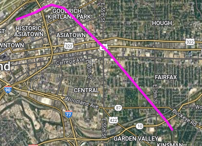
OK, I am sorry to hear this, but I might see what has led you there. Anyway, does anyone know who owns the track marked in purple?
-
I asked because you wrote this "I estimate a running time of 35 minutes (vs 60-75 minutes by bus) from the Crocker/Bassett station to Tower City Center. Headways of 15 minutes from 4 a.m. to 1 a.m. Eastbound trains would wait at the east end of extended double-track West Clifton station in Lakewood for the westbound train to pass, then enter single track across Lakewood. When the eastbound returns to double track at West 110th Street, the next westbound is allowed to enter the Lakewood single track." and I wasn't really sure what you meant but was it that there would just be a small stretch of single track somewhere? Btw, how is the system signalled on the grade separated parts?
-
Is there some way that GCRTA could get some federal funds for an upgrade of the ticket system? For the lakewood branch you posted in april last year here, am I getting you right that you imagine it to be double track to the Rocky River and then single track until the terminus? Or just single track crossing the Rocky river?
-
@Boomerang_BrianThe green line expansion seems like a fairly logical extension, did @KJP try to cost it? Re the regional rail improving the existing sytem should of course go before maybe a new systm, but OTH it would be interesting to see at least a feasibility study for an in-county commuter rail. To see if two branches, one from Bedford and one from Solon who on the shared parts could have stations at E79 (Interchange), Euclid Av, Lakefront (interchange), W Blvd -Cudell and Hopkins intl airport. It might make the current waterfront line more useful, wouldn't it? Speaking of that @Ethan, haven't extending the waterfron line as a tram/streetcar line? dor example converting bus line 1 by a ramp either from North coast stn up onto E12st and then to the current line 1 terminus alternatively after south harbor station and upon E18st with stations every halfmile downtown and 0,6-0,8 further out. Lastly, I played around a bit with the GCRTA interactive map, and I noticed there are many of the high frequency bus lines that come into the city centre and then reverses. Have it been considered to merge some buslines to crate through lines? For example merging line 22 with line 3 (and maybe 28-28A?) or merging the health line with 51-51A and so on?
-
Re the green line, is it a bit of going through low density neighburhoods and a bit of having a low frequency? Would it be possible to redirect it close to the eastern terminus? Btw at tower city center, are there reserve platforms available that could handle through traffic? For the commuter rail study, a fully built system would have three branches so there might been enough services in the central part to almost have an S-Bahn-system in the city centre maybe? Did the study suggest any train frequencies? Is the commuter rail system thing completely dead now? Btw, how does it work legally to run a transport scheme that runs traffic in more than one county?
-
Oh, re the 5-minute I have never thought about it that way, but I guess if you use 10 minute circles you need to have some overlap anyway and in a dense citycape there could of course be closer spacing if not to avoind voercrowding platforms. And for the new rolling stock I was just curious to see if GCRTA could save some money by having similar stock as other cities. BTW, how are GCRTA's finances? I quickly googled and they seem to state that they had greater income than expenses but there might be more than that? Also the comuter rail that is mentioned sometimes, where only the Solon to Lorraine seemed to make sense, what were the other destinations? How would pass through central Cleveland, passed Tower city station or through the lakeside Amtrack station?
-
OK, thank you for your answer. It's not quite what I suggested but I get your general point of walking distance from stations. Speaking of that it seems often in this thread that stations are expected to have an uptake from an area 5 minutes walking distance from them, but I have in most other discussions on these matters encountered an expectations of 10 minutes walking distance. (Of course in dense environments shorter distances might be OK). Another question, for the new rolling stock, does anyone know if they will be more like the Calgary vehicles or more like the shorter and more nimble SF-vehicles? Btw, might as well get this out at the start; I'm not a Clevelander or American, so my interest in this thread is not to get a better commute or something like that. Just a nerdy fascination with this system with so much unused potential. So there will probably be more questions later.
-
A question, how does this compare to a similar overall line but instead connecting Cedar Avenue to Euclid Avenue via either MLK Jr Drive and/or Stearns Drive and a interchange stop where the blue passes under the red line?
