jam40jeff
Jeddah Tower 3,281'
-
Joined
-
Last visited
Everything posted by jam40jeff
-
Free Parking, it's a constitutional right!
-
The last I heard it is... https://www.cleveland.com/travel/2019/01/river-bend-hotel-planned-for-ashtabulas-harbor-district-is-towns-first-new-hotel-in-100-years.html EDIT: I just saw your more recent update on the Ashtabula thread. Good news!
-
Although Ashtabula has two "downtowns" of sorts. Main St. (at least more so than Painesville's Main St.) is still fairly intact, although there are a lot of vacancies and the buildings have a rundown feel. "The Harbor" is kept up very nicely (and actually seems to be thriving with businesses). https://www.google.com/maps/@41.8999556,-80.7984823,3a,75y,266.48h,89.37t/data=!3m6!1e1!3m4!1sKlsXbTvb4dP-OUDi5wZrkw!2e0!7i13312!8i6656
-
It has to be a city/county merger or bust. Then this wouldn't be the narrative anymore... https://www.msn.com/en-us/money/realestate/worst-cities-to-live-in-every-state/ss-AAApyNv?ocid=spartanntp#image=36
-
No way that happens...the platform would be 0.2 miles from the one at Little Italy.
-
And, yet, it's easily accessible by Metro.
-
Maybe they're really just both built by Ryan Homes.
-
Reduced travel time would be great, but would it really reduce operating costs that much? A 3 minute shorter ride would be great for everyone and may help increase ridership, but wouldn't it either mean more trips due to decreased headways or drivers sitting idle for 3 more minutes at the end of the route? While some costs would be reduced (energy savings) the man hours would still be the same, so it wouldn't be a linear savings.
-
Try the app Maps Ruler, but your point stands. Richmond Mall to Tower City - 10.7 miles Harry Buffalo to Tower City - 7.1 miles Crocker Park to Tower City - 13.7 miles St. John West Shore Hospital (or whatever it's called now) to Tower City - 10.1 miles And just to show how sprawly things quickly get to the South... I-77 and Rockside Rd. to Tower City - 7.3 miles I-77 and Pleasant Valley Rd. to Tower City - 9.6 miles
-
People from the West side think Coventry is the far East side and that Bay Village is an inner ring suburb.
-
The retail must be retained as there are signs up for Burgerim and Tacologist, unless those have come down.
-
But where do people from Columbus have to go to get them some Hermès? ?
-
Sorry, I didn't word it very well, but that's what I meant (that the diagonal was Central and not Cedar.) The view is down Central, with E. 14th crossing and Carnegie heading off diagonally slightly to the left in the background. Part of Central north of the Innerbelt still exists, or at least did before the new Innerbelt bridge was completed. (I'm not sure if it survived that project or not.) https://www.google.com/maps/@41.4974349,-81.6779551,3a,75y,273.79h,83.06t/data=!3m6!1e1!3m4!1ssH5OKv-Mj3xPl2h3zUy93w!2e0!7i13312!8i6656
-
I believe that's actually Central, as Cedar ended at E. 22nd.
-
I was referring more to how you determined the area under a specific density. What was the unit of area you used to determine the densities (block group, tract, etc.)? How did you find the set of data for that unit for the entire city? I chose census tracts as my unit and the county as the overall area to study both because I find tract data to be more meaningful when looking at "local densities" (it's not too small of an area to produce outlandish results but also not too big to lose the granularity required to compare relative densities within a city) and also because AFF makes it easiest to obtain this tract data for an entire county.
-
AT&T is the worst. Like worse than Spectrum bad. I wouldn't believe a thing they say.
-
@jonoh81 I just saw this... My numbers are from the 2010 census. I don't use estimates because I find them to be too inaccurate. I will link to the spreadsheets I used for Cuyahoga County and Franklin County. They were downloaded straight from the Census AFF site. The only modifications I made were to sort by density descending, then calculate the averages above certain thresholds. If you want to find the data yourself, go to https://factfinder.census.gov/faces/nav/jsf/pages/searchresults.xhtml?refresh=t, search for "Population, Housing Units, Area, and Density: 2010 - County -- Census Tract", add Cuyahoga County and Franklin County as your geographies, and off you go. You'll get the same data I attached. If you find an error in my calculations, let me know. Cuyahoga County - https://1drv.ms/u/s!AqRDK8hd4pDOgYcmYqNpWft4IZSDQA Franklin County - https://1drv.ms/f/s!AqRDK8hd4pDOgYcoKdNhqLTjMaGUQg As far as your numbers go, how did you find them?
-
Not only do the rich keep getting richer as far as metros go, the suburbs keep getting more suburban. This doesn't surprise me at all. Apple and many other tech giants are about as anti-urban as they come. Also, I feel like Austin is about as overhyped as Nashville.
-
You're using a small unit of measure and an outlier to prove a point. The densest block group in the United States is in Chicago. It has a population of 978, covers 0.0016 square miles (roughly 180 ft x 180 ft square, just over half of a football field), and has a density of 600,809 person per square mile, about ten times higher than Manhattan. What does that tell us? That using a single block group as an anecdote for pretty much anything is meaningless. Let's use some real statistics... I sorted every census tract in Cuyahoga County and Franklin County by density and then computed some summary information. Land area within a census tract that has a population density of 10,000 persons per square mile or higher: Cuyahoga County - 8.75 square miles Franklin County - 2.05 square miles Population living in a census tract that has a population density of 10,000 persons per square mile or higher: Cuyahoga County - 102,230 Franklin County - 38,684 Repeating this analysis with a cutoff of 7,500 persons per square mile or higher yields the following: Land area within a census tract that has a population density of 7,500 persons per square mile or higher: Cuyahoga County - 30.16 square miles Franklin County - 12.72 square miles Population living in a census tract that has a population density of 7,500 persons per square mile or higher: Cuyahoga County - 283,358 Franklin County - 128,709
-
Oh, absolutely, I would never disagree with you there. Like Pittsburgh, the topography in Cincinnati definitely forced things to be built much more densely in the areas that are suitable for building than either Cleveland or Columbus.
-
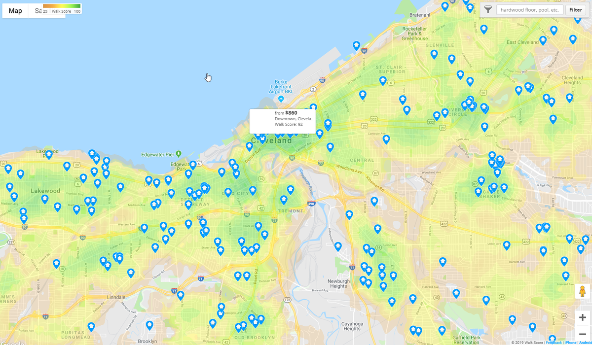
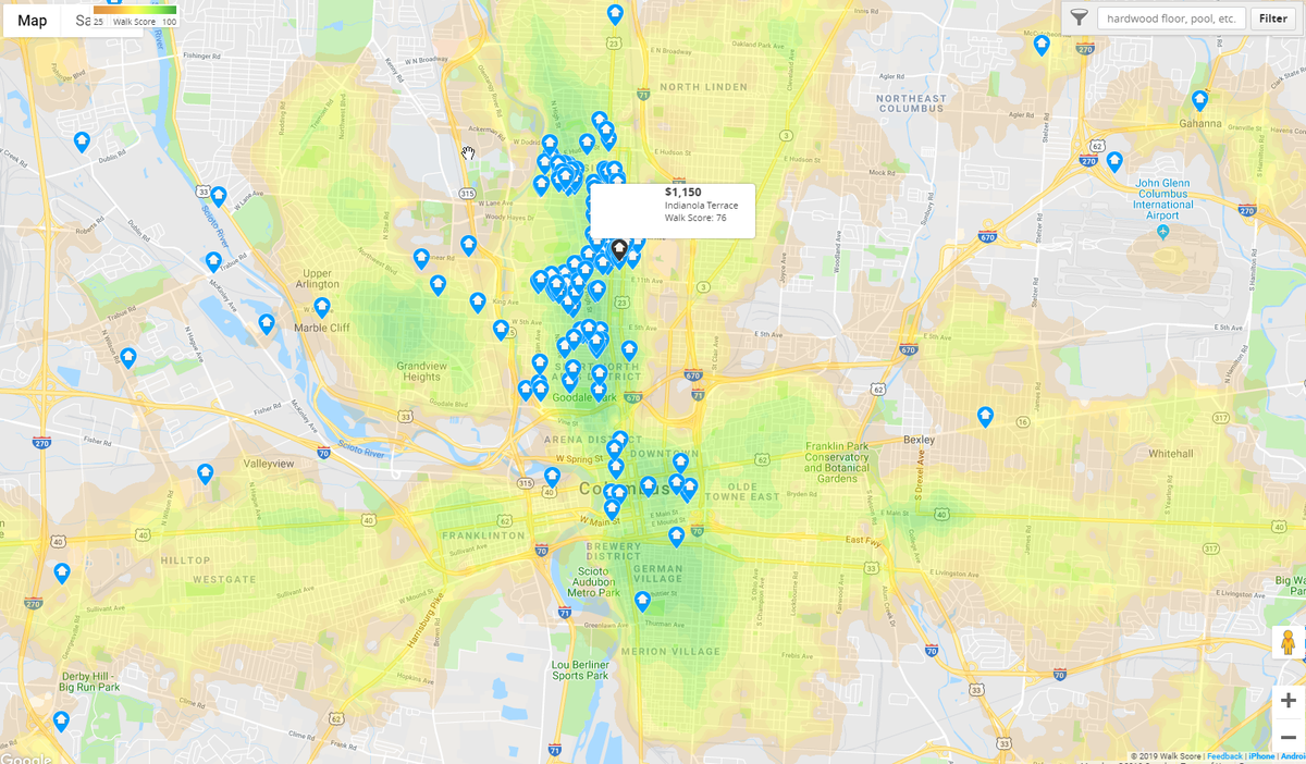
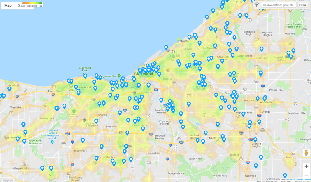
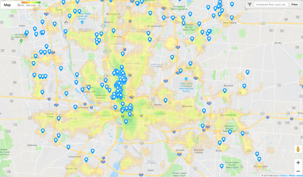
First of all, Cleveland has more historical density than Columbus, so even if there are a lot of vacancies, its built environment will still be more dense. Also, Cleveland is more walkable, which I think is what a lot of people are referring to when they say something "feels dense." I know the walk scores were posted before (and that WalkScore.com isn't a perfect measure by any means), but I will attach the walk score heat maps for each city as well, where you can see that Cleveland has more green and yellow areas than Columbus (although the stretch between Ohio State and German Village is a nice contiguous stretch of walkability, as we all know, not many other areas of the city are walkable). The images with the 2 suffix are zoomed one step further out than the default zoom level.


-
https://www.census.gov/geo/maps-data/maps/2010ua.html Cincinnati: https://www2.census.gov/geo/maps/dc10map/UAUC_RefMap/ua/ua16885_cincinnati_oh--ky--in/DC10UA16885.pdf Cleveland: https://www2.census.gov/geo/maps/dc10map/UAUC_RefMap/ua/ua17668_cleveland_oh/DC10UA17668.pdf Columbus: https://www2.census.gov/geo/maps/dc10map/UAUC_RefMap/ua/ua19234_columbus_oh/DC10UA19234.pdf
-
This. I believe most of us concluded at one point on here that the Urbanized Area definitions of the census are probably the best way to compare different cities. I'm actually unsure why those aren't more well known than the MSA definitions.
-
"No reason"? That's quite a stretch. There are quite urban densities spreading east and west from the city outside of the 5 mile radius. It's likely that much of that density would have been built north of the city if that land was available. I would think people living in those dense areas 5-8 miles from the city would have preferred to live within 5 miles of the city if they could enjoy the same densities and be closer to the city due to there being land available north of the city. People also have a "density preference" in addition to a "distance from the city center" preference. Both were likely at play, but as long as the "density preference" played any part in people's decision to move further away from the city, then that means more people would have located within the 5 mile radius if they were able to be closer to the city with the same density as they had to seek further east or west.
-
I don't see what misconceptions this shows. Nobody is arguing that there's no density in Columbus, but there is a lot of medium density, car-centric development. Even with all of the bombed out areas of Cleveland, it is still 20% more dense than Columbus. If you include Lakewood, the Heights, et al in those numbers, the density goes up even higher. Also, we've been over this before, but dense is not the same as urban.